OTHER PROJECTS
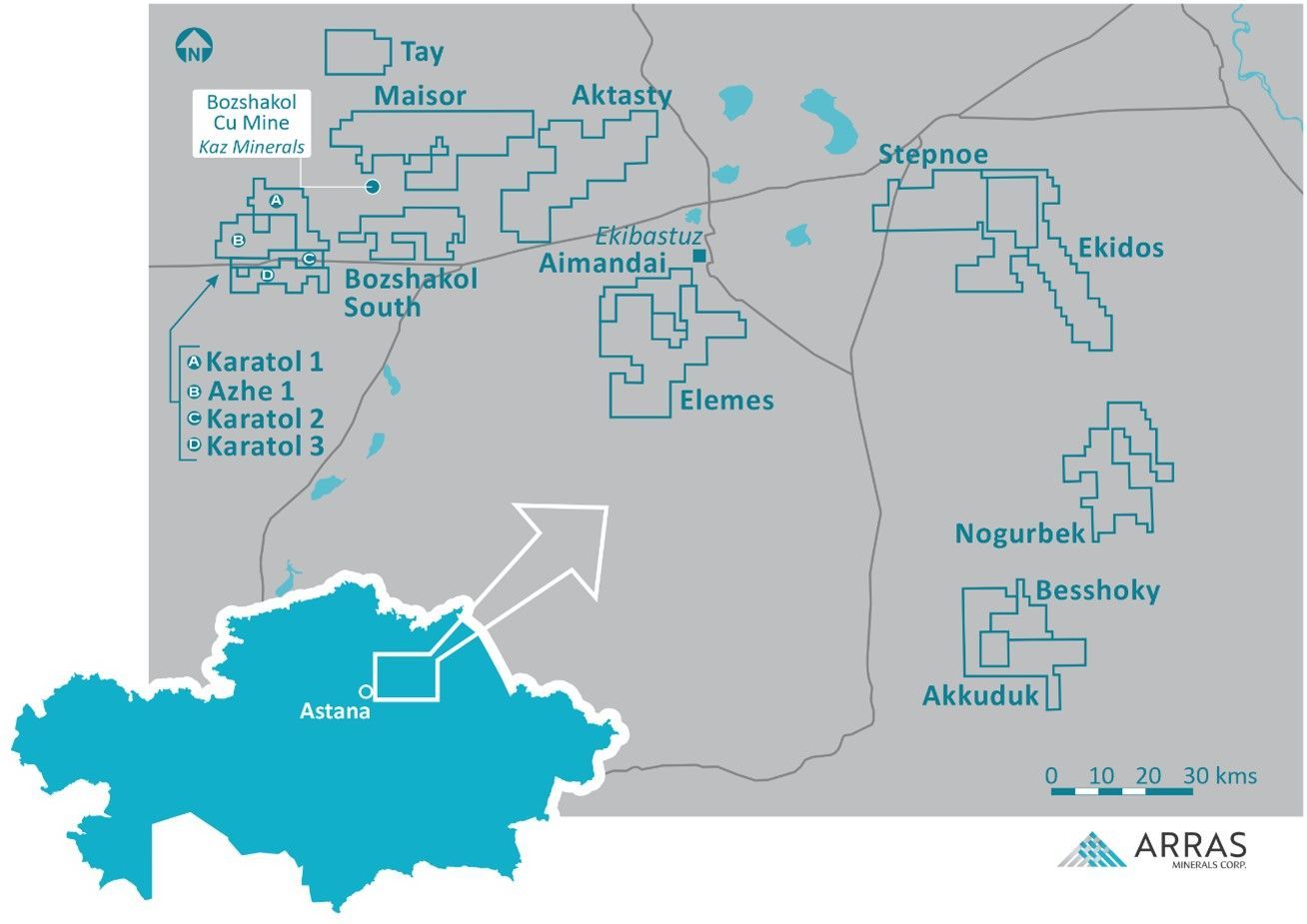
Arras Minerals Elemes Project and project portfolio with reference to the Bozshakol copper mine located in Pavlodar, Northeastern Kazakhstan
Arras Minerals controls approximately 3,300 sq km of mineral licenses in Pavlodar Region of northeastern Kazakhstan. Until Arras acquired this license package through staking starting in 2021, most of the historical exploration work across the package was limited to Soviet-era work including regional geophysics along with some Top of Bedrock (KGK) drilling and minimal core drilling in certain areas.
Approximately 1,900 sq km of this land package was included as part of the Arras-Teck Strategic Alliance announced in December 2023. Under the Alliance, Teck Resources Limited (“Teck”) funded US$5 million of generative exploration work through 2024-2025 which included geophysics, soil sampling and mapping, KGK drilling and approximately 5,000m of diamond drilling (18 holes). At the conclusion of the generative program, 100% of the Alliance license package reverted back to Arras in Q1 2026.
Across the license packages, there is very little to no outcrop with unconsolidated cover usually ranging from a few metres to up to 40m in thickness.
Bozshakol Group of Licenses
The following work has been completed on the Bozshakol Group of Licenses:
- 39,773 soil samples collected
- 3,641.7 line-km Heli-EM survey
- 181.4 sq km VIP survey
- 135.4 line-kilometre Pole-Dipole (P-DP) Inducted Polarization survey
- 479 Top of Bedrock (“KGK”) drill-holes totaling 12,555.2m
- 18 diamond drill-holes, totalling 5,250.6m
In the western part of the license package, where cover was minimal, more than 39,000 soil samples were completed. In the eastern part of the license package, where soil cover was thicker, a systematic grid of KGK drilling totaling 479 holes (12,555.2m) was undertaken to identify any mineralization beneath cover and to learn more about the subsurface geology in these areas.
Work undertaken by the Arras-Teck Strategic Alliance defined multiple new porphyry systems in the project area. These include:
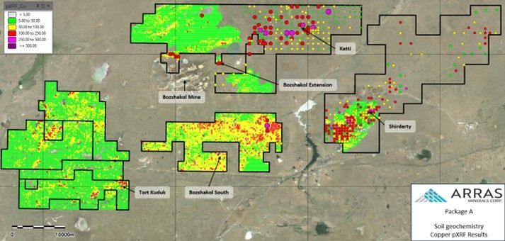
Soil (small points) and KGK (large points) Copper values with principal exploration targets.
Shirderty Target
The KGK drilling outlined a large Cu-Au-Mo-Bi-Te anomaly in a NE-SW striking structural corridor, with a coincident 4km x 3.2km chargeability anomaly and discrete magnetic lows.
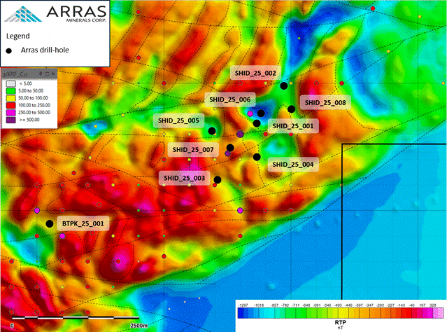
Shirderty Target showing completed drill-holes overlain on VIP chargeability anomaly and KGK Copper values.
Diamond drilling (8 holes, totaling 2,159.4m) intersected several phases of intrusive rocks and several syn-mineral porphyry dikes hosted in mafic volcaniclastic rocks with extensive porphyry style alteration and mineralization, consisting of a core of phyllic alteration with D- and B-Type veins and 3-5% disseminated pyrite, that is surrounded by an extensive zone of propylitic alteration with quartz-pyrite-chalcopyrite-albite-chlorite veins. The results are indicative of the peripheral part of a porphyry system, and the 2025 drilling only tested a small part of the target.
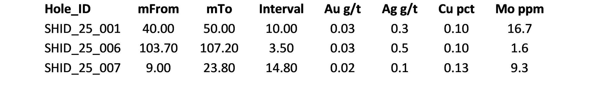
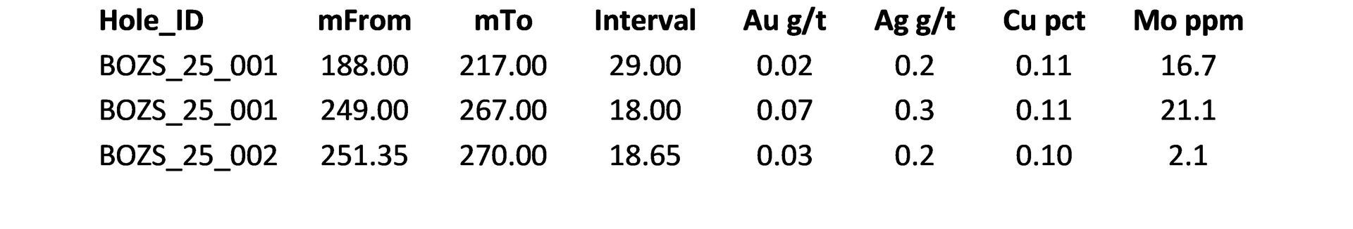
Shirderty Drill Results
Table 1: Selected drill results, Shirderty Target
Bozshakol South (“Boz S”) Target
The target is defined by a 3x2km wide chargeability anomaly in Soviet-era data centered on a small gold-barite. The area was tested with a single IP line that confirmed the size and scale of the historic anomaly and soil sampling identified large soil Cu, As, Mo anomalies coincident it.
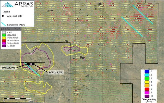
Bozshakol South Target showing completed drill-holes, completed IP lines and historic chargeability anomalies, overlain on soil pXRF copper values.
This target was only explored by two wide-spaced drill-holes that intersected intrusive rocks with phyllic and propylitic alteration that is indicative of the distal part of a porphyry system. Mineralization consisted of disseminated pyrite, with minor magnetite patches with zones of quartz-pyrite-chalcopyrite veins and C-type veins. Drill results include:
Table 2: Selected drill results, Boz S Target
Tort Kuduk Target
The target is defined by a 1 x 1 km Mo-Cu soil geochemical anomaly. Mapping identified several areas of outcropping silicified intrusions with a high density stockwork quartz veining and strong potassic alteration.
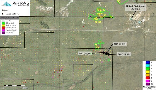
Tort Kuduk target with completed drill-holes overlain on soil pXRF Cu data and historic chargeability anomalies.
Three wide-spaced holes to a maximum depth of 300m. one of these hoes,
TORT25003, that intersected a porphyritic monzonite hosted in andesites with zones of stockwork A- and B-type veins with k-feldspar halos.
Table 3: Selected results from Tort Kuduk Drilling

Bozshakol Extension
Arras controls an approximate 1.2km extension of the operating Bozshakol copper-gold mine trend that cover parts of a large historic chargeability anomaly. Soil sampling and KGK drilling returned porphyry pathfinder signatures and suggests that a second porphyry center may occur to the northeast of the Bozshakol Mine on Arras’ licenses.
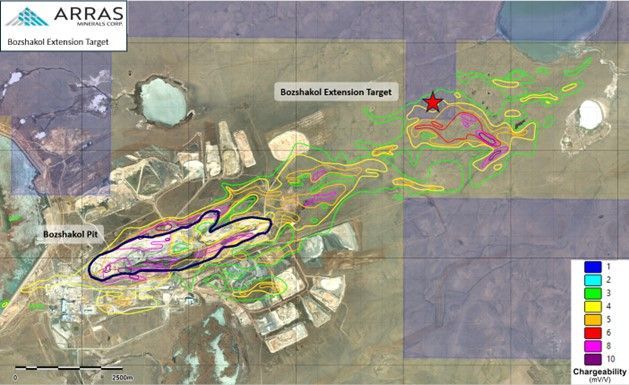
Location of the Bozshakol Extension Target related to historic chargeability anomalies and Bozshakol Mine. Arras License areas in shaded grey blocks.
Akkuduk Group of Licenses (Akkuduk, Besshoky, Nogurbek)
The following work has been completed on the Akkuduk Group of Licenses:
- 21,661 soil samples collected
- 145.7 line-km Heli-EM survey
- 47.5 line-km P-DP survey
- 3 diamond drill-holes, totalling 1,200.2m
The Akkuduk Group of licenses cover a number of diorite intrusion that have been emplaced into Ordovician, Carboniferous, and Devonian volcanic, volcaniclastic, and sedimentary rocks. Three large, northwest-southeast striking regional faults cut through the property, bringing together several different litho-tectonic terranes, each host a distinct style of mineralization, including:
- Cu-Au porphyry mineralization
- Orthomagmatic sulphides Ni-Cu ± Co, PGE mineralization
- Au-rich VHMS (Cu-Au-Ag-Zn-Pb)
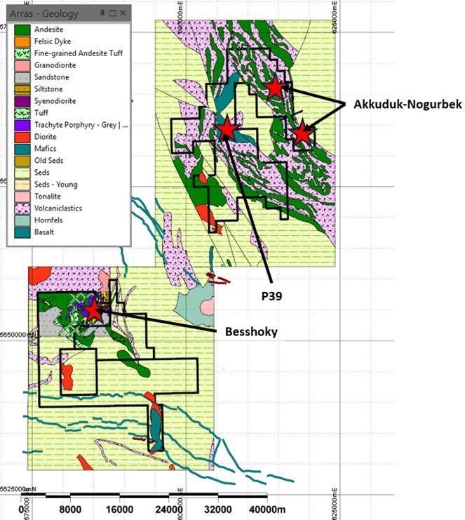
Akkuduk Group licenses with principal targets overlain on interpreted geology.
Besshoky Target
The Besshoky target is a broad hydrothermal system covering >35 sq km with a core of silicification and pyrophyllite-white mica, sericite-quartz-pyrite and grading to chlorite-epidote-magnetite alteration towards the edges of the system.
Soil sampling defined a large Cu-Mo-Bi geochemical anomaly centred on this lithocap. Follow-up IP surveys, totalling 47.5 line-kilometres, identified several large chargeability anomalies beneath and adjacent to it.
In 2025, three wide-spaced holes were drilled in the lithocap. The holes intersected a package of andesitic volcanic breccias and andesite flows with strong sericite-quartz-pyrite alteration with an increase in potassic alteration with depth, suggesting that the core of the system is located towards the south-east part of the lithocap, and was not fully drill tested.
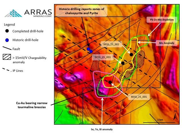
Besshoky Target with completed drill-holes, showing chargeability and geochemical anomalies overline on airborne magnetic data (reduced to pole).
Akkuduk-Nogurbek
Arras geologists have identified several historic drill-collars in the field, and summary information in Soviet-era reports indicated significant gold intercepts hosted in diorites. Significant historic intercepts reported from the Akkuduk-Norgubek drilling include:
- 30.5 m grading 1.65 g/t Au
- 30.2 m grading 1.07 g/t Au
- 19.8 m grading 1.2 g/t Au
Soil Sampling highlighted by a minor Cu-Mo soil anomaly with a coincident significant Ni-Mn depletion zone at the Akkuduk Target.
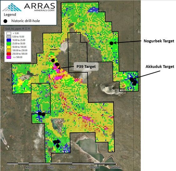
Nogurbek License showing historic drill-holes and principal targets overlain on pXRF Nickel soil data.
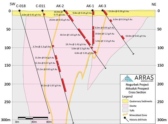
Section through Akkuduk Target, showing historic gold intercepts. Exact locations of these drill-holes are unknown.
This data suggests that there is good potential for this target to host significant gold mineralization.
P39
The Company believes that the P39 target may host an orthomagmatic nickel sulphide deposit. Soil sampling in 2023 defined a 14-kilometre-long Ni-Cr-Co anomaly (figure 10) and a small EM survey conducted in 2024 identified a series of subtle EM anomalies coincident with the core of the Ni-Cr zone and may represent sulphide mineralization. A couple of historic drill-collars have been found to the north of the P39 target. The Company believes that these holes were drilled during the Soviet-era, and, unfortunately, have not been able to find any information on them.
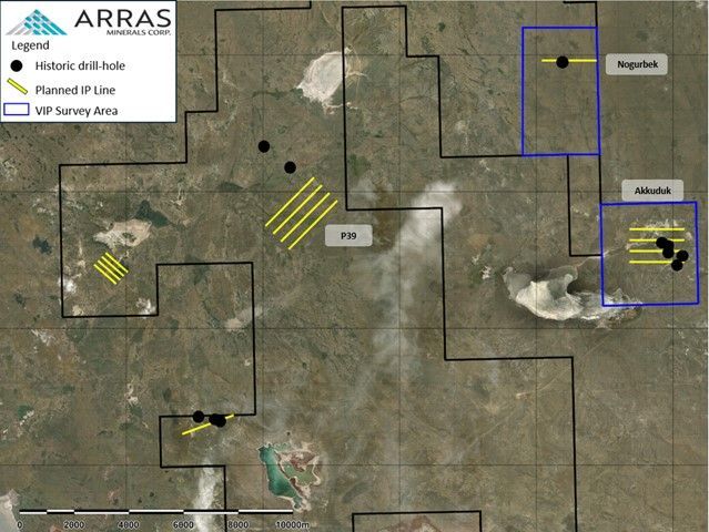
Plan map showing historic drill collars located in the field by Arras geologists and planned geophysics surveys.